A View From The Top
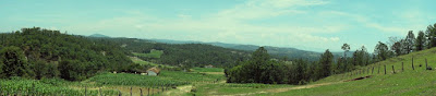
This a panoramic view of the aldea Quiaquizuyal. This frontier like photo was taken a couple months ago, although could easily have been taken a hundred years ago as not much has
changed in the rural areas of Guatemala. Houses are still constructed with adobe or mud blocks, there is no running water, no electricity, and a majority of the homes still have dirt floors.

This is a photo of Don Luis. Don Luis is an employee of the Municipality and acts as a right hand man to the Mayor. Here he is standing in the back of a pick-up truck looking over the hills of Huehuetenango. The mountain range in the background is the Cuchumatanes. He accompanied us out to Xepon, one of the farthest out villages, and joined us for the free ride back to the centro of Malacas. As you can see by this photo, many of the roads in Huehuetenango are of dirt. I'd say that 10% or less of roads in this part of the country are properly paved.
 This is a photo I took last year in September of 2010. I was returning from a visit to Plan Grande and decided to take a self-timed photo of the gorgeous countryside. The centro of Malacas is somewhere over my right shoulder and about 4 more miles away. Guatemala is beautiful this time of year. The rainy season has left the mountains green, which is a nice change from the desolate yellowish landscape that was leftover from the dry season. Colder weather is slowly creeping towards Huehuetenango and this will be my last "winter" in Guatemala as my planned COS(close of service) date is March of 2012.
Comments
Post a Comment